
Return to Home Page
Special Features
What Did Our Train Depots Look Like?
The 1873 H.&T.C. Depot
NOTE: THIS IS A REVISED VERSION OF THIS PAGE, MADE NECESSARY DUE TO "NEW" INFORMATION COMING TO LIGHT.
On April 19, 1873, The Dallas Weekly Herald, a newspaper that no longer exists, published a letter dated April 14, 1873, from a correspondent who called himself (or herself?) "Richardson," posting it from "Richardson, Dallas County, Texas." Among other things, the letter said this: "Richardson is soon to be a depot on the H.&T.C. R.R., near old Breckenridge, in this county."
So far as it is known, this was the first time ever that the name "Richardson" was applied to the place, and specifically to the train depot that the Houston & Texas Central Railway was then building at that place, in the literal middle of what is now called the original town of Richardson, or as I prefer to call it, "Historic Downtown Richardson," or the "Historic Heart," even if neither of those terms are its official appelation.
What did that depot look like?
Since 2022, when I wrote and published the first volume of A Sesquicentennial History of Richardson, Texas, I have tried to find out, so far without success. Why? Because unfortunately, there is no known sketch, photograph, painting or blue-print of that 1873 depot. If any one of those things does exist, it has not yet come to light.
Until recently (August 2026), all we had to go by was a map, drawn by railroad surveyor Theodore Kosse in 1873 (and again in 1878), which purports to show the position and approximate size and shape of the depot and the platform upon which it sat. (See map below.)
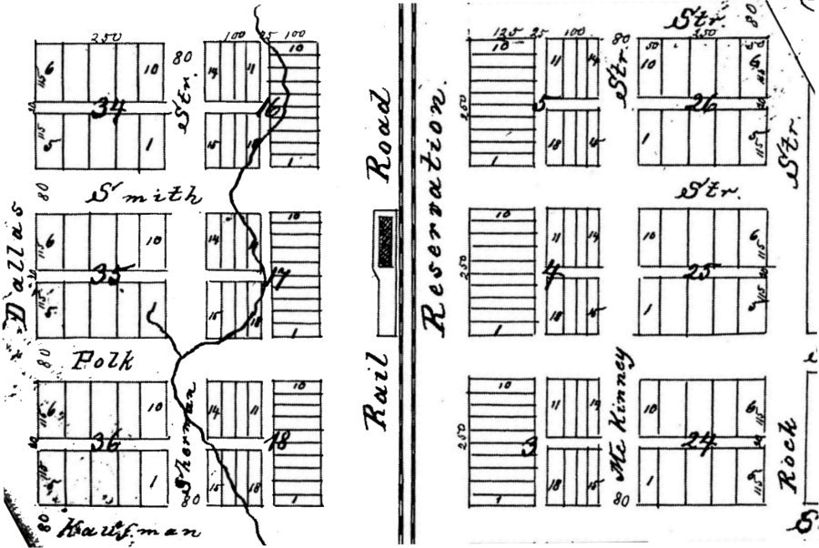
Map of the "Historic Heart of Richardson, Texas drawn by Theodore Kosse
Unfortunately, both the 1873 and the 1878 map were misleading. According to Kosse, the depot stood on the west side of a "Railroad Reservation," between Smith Street (now Main-Belt Line) on the north and Polk Street on the south. The map also shows the dimensions of the blocks and lots into which he divided the city, with each block measuring 250 feet square and the lots in Blocks 17 and 4, on either side of the depot, measuring 25 feet in width by 125 feet in length.
Although those block and lot measurements are accurate, Kosse exaggerated the size of the Railroad Reservation, making it 300 feet wide. He also exaggerated the size of the platform upon which the depot sat, making it 250 feet long, stretching from Smith Street to Polk Street. I don't know why.
So, what's the real story?
Recently, three H.&T.C. survey maps of the railroad reservation in Richardson, dating from 1894, 1907, and 1909, have come to light and what they demonstrate is that Kosse was wrong about the width of the reservation as well as the location and the size of the train depot. According to both maps drawn by Kosse, the depot was as wide as a city lot--namely 25 feet--and a little short of the length of a lot (100 feet), with the platform on which the depot sat being about 50 feet wide at the north end and about 25 feet wide at the south end. But, as I say, those measurements were wrong.
Here is the 1894 survey map, based on a field inspection.
.jpg)
1894 Survey Map of H&TC Railroad Reservation
The first thing I noticed is that though the depot is still on the west side of the tracks, in the later surveys it is a block north of where Kosse placed it, between Smith (now Main) Street on the south and Tyler Street on the north (rather than between Smith and Polk).
The next thing I noticed is the shape of the platform on which the depot sat. In the later surveys it is a simple rectangle, not narrow at one end and wide at the other, as Kosse depicted it.
I also noticed that all three of the later surveys give all or most of the exact dimensions of both the platform and the depot, with all three surveys agreeing that the platform was 42 feet wide and that the depot itself was 24 feet wide. Two of the surveys (1894 and 1907) say the depot itself was 80.2 feet long. The 1909 survey doesn't say. None specifically give the length of the platform, but that is easily deduced from the other measurements given.
Two of the surveys (1894 and 1907) likewise agree that the distance from the north end of the depot to the north of the platform was 54.7 feet, but for some reason, they differ as to the measurements around the depot on the south, east, and west sides.
Here are the measurements around the depot on the south, east, and west sides, from each survey.
1894: West side: doesn't say; South side: 6 or 9 feet; East side: doesn't say.
1907: West side: 10 feet; South side: 9 feet; East side: either 4 or 8 feet (there are two numbers in this area). This would make the platform 42 feet wide if we add 10 and 8 and 24 feet for the depot itself. But if you use 4 feet for the east side, the platform falls 4 feet short of 42 feet. I don't know why there are two numbers in that space. Clearly, 4 feet is an error.
1909: West side: 10 feet; South side: 10 feet; East side: 8 feet. The east and west measurements, combined with the 24 feet width of the depot, comes to 42 feet.
So, if we add 54.7 feet from the north end of the platform to the north end of the depot, then 80.2 feet for the depot, and then 10 feet from the south end of the depot to the south end of the platform, we get a platform 144.9 feet long, but it we make the south end only 9 feet wide, the platform is 143.9 feet long. Not a lot of difference though. Either way, it's almost 145 feet long.
Unfortunately, all these measurements cannot tell us how high the depot was, or anything else about its general appearance.
However, during the same period that the Houston & Texas Central Railway was laying tracks across North Texas toward Denison, it was building depots not just at Richardson but also at several other places, some of which previously existed and some of which were brand new, like Richardson. It is reasonable to assume therefore, that in those brand new places, the same type or style of depot was constructed. Unfortunately, we don't know this for a fact, in light of a lack of evidence, but logic dictates that conclusion.
So, what were those other brand-new places?
During the Northern Expansion period (1870-1873), there were twelve places that did not previously exist. They were (from south to north): Groesbeck, Mexia, Thornton, Wortham, Ennis, Palmer, Hutchins, Richardson, Allen, Anna, Van Alstyne, and Howe.
Next question: Is the original depot in any of those places other than Richardson still standing more than 150 years later?
Answer: There's only one, in Anna, Texas, which was built in the mid-1880s, not the 1870s.
Second Question: Are there any photographs or pictures of the depots that aren't still standing?
Answer: Yes, there are some. Unfortunately, they show a variety of buildings, not all of which are the original 1870s-era depots. Some (perhaps all) are probably either later buildings or altered original structures. Consequently, they are not helpful in determining precisely what the 1873 Richardson depot looked like. On the other hand, they can give us a general idea. One of these is the old depot museum at Anna, Texas, which was also on the H.&T.C. line to Denison, a little more than 30 miles north of Richardson.
Here are some photos of the Anna, Texas H.&T.C. Depot, taken by me on Saturday, August 8, 2026. Built in 1885, it is the oldest train depot still standing in the whole state of Texas. It is open on the second and fourth Saturday of each month from 10 a.m. to 2 p.m. When I visited, the volunteers that man the museum inside were very friendly and helpful.
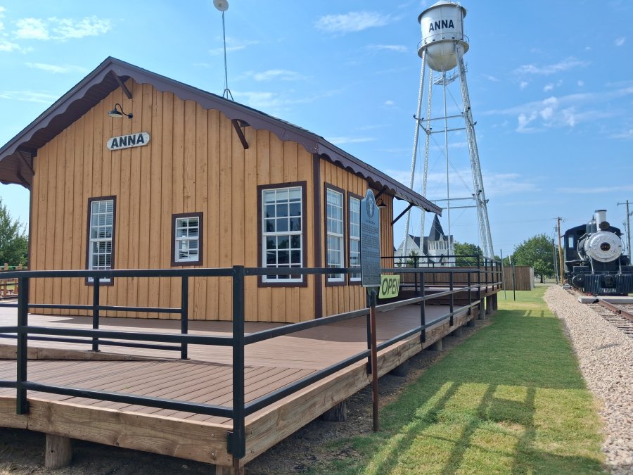
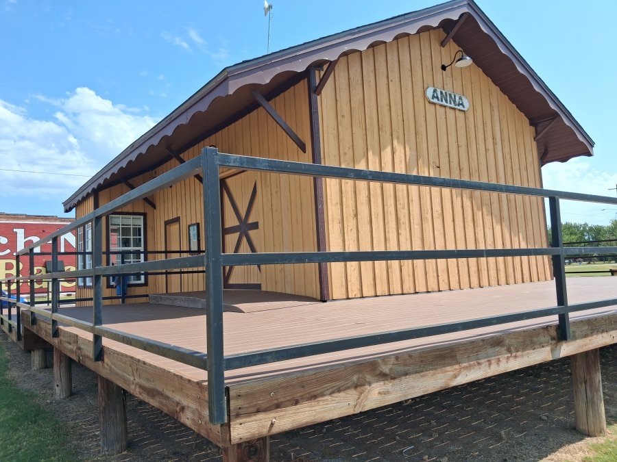
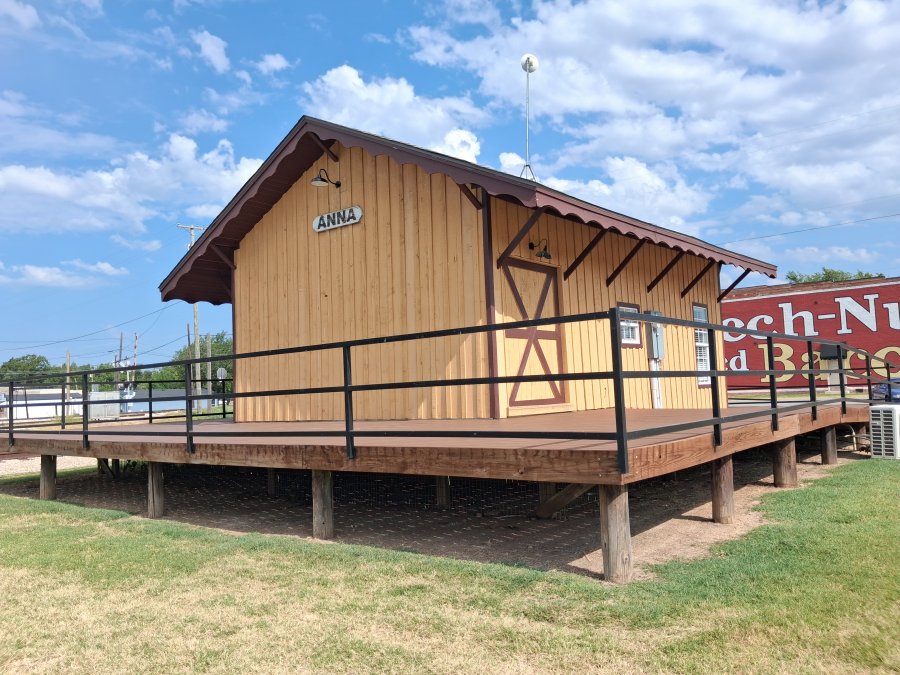
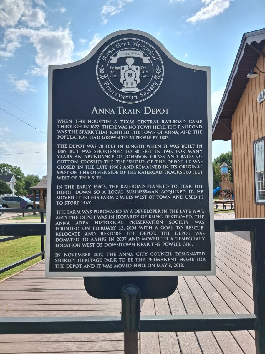
So, is this what the 1873 Richardson depot looked like? Could be.
One more observation about the newly-discovered maps: Both the 1894 and 1907 Richardson Railroad Reservation Maps show the location of a grave which by my estimate is about 225 feet (or 75 yards) past the north end of the 1873 depot platform (or 370 feet from the south end). This is almost certainly the grave of an H.&T.C. Roadmaster named Patrick J. Burke, which was written about in a Dallas Morning News report about Richardson, on January 17, 1896. It read as follows:
"This [Richardson] is the first Dallas county town the southbound Houston and Texas Central train reaches. It is about 3 miles south of the Collin County line. Just as the train slows up at the depot, the passenger may see a little picket enclosure of about 4x7 feet in size alongside of the railroad track, and he wonders who the lone sleeper was that rests there in his narrow bed dug out of the black waxy soil of Dallas County. If he asks the conductor about it, he will be told that the 'lone grave at Richardson' is that of an early roadmaster of this line named Burke, who died of small-pox and was interred in this solitary grave upon the right-of-way of the road. The section boss of this part of the road is required by the company to take care of Burke's grave and keep up the pickets. In his lonely tenement, this once faithful employe of the road is still near the work he loved in life and his ashes are gently shaken by the passing trains."
After more than 130 years or so, the grave is now unmarked.
Here is a portion of the 1907 railroad reservation map that shows both the depot and the grave to the left.
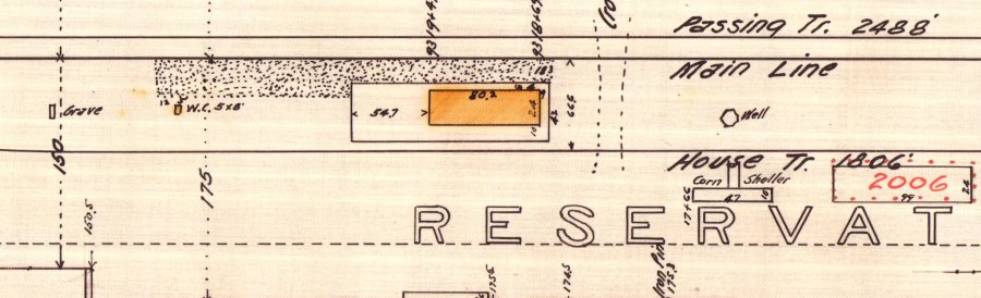
SEE "NEWS AND VIEWS" post of August 18, 2026 for more information about the Roadmaster's Lonely Grave.
CONTINUE TO THE 1907 Depot
This website copyright © 2021-2026 (except where noted) by Steven Butler, Ph.D. All rights reserved.
